Agricultural drought monitoring using GIS and remote sensing data from 2001 to 2021 and it’s prediction based on deep learning techniques
The problem
Due to its geographic location and climate, Central Asia is vulnerable to desertification, land degradation and drought, and much of the land has already been affected.
According to the United Nations Development Program report, “Strategic measures to combat desertification in the Republic of Kazakhstan until 2025”, Kazakhstan loses about 93 billion tenge annually due to desertification, land degradation and drought.
The northern grain-sowing regions of Kazakhstan, where 73% of the sown area of agricultural crops is concentrated, include the North Kazakhstan, Kostanay, Akmola and Pavlodar regions (more than 565 thousand sq. km). According to the Köppen-Geiger classification, more than 80% of the cultivated area is located mainly in the cold semi-arid natural zone. Given that the lion's share is rainfed crops, i.e. agricultural crops are cultivated without artificial irrigation, drought is the main threat of crop failure. Therefore, there is a need for monitoring and forecasting agricultural drought throughout the Republic.
Main approach
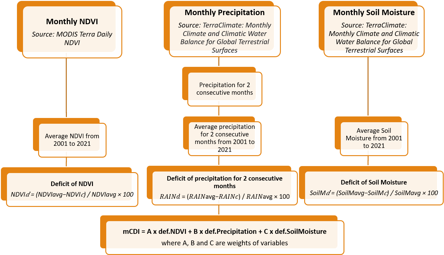
Agricultural drought occurs when crop yields are below normal due to a prolonged lack of soil moisture in the root zone caused by less-than-normal rainfall (Vyas et al., 2015). Three remote sensing products were used in this study: NDVI, precipitation, and soil moisture, which reflect, respectively, the intensity of vegetation and the main soil water supply during the growing season. Agricultural drought was monitored and predicted using a modified Combined Deficit Index (mCDI) based on the monthly deficit of NDVI, precipitation, and soil moisture. All the input parameters for 20 years period are available on the Historical Data page.
All the proccessing was carried out on the Google Earth Engine cloud platform. Source codes available on the GEE platform
Validation of modified Combined Deficit Index (mCDI)
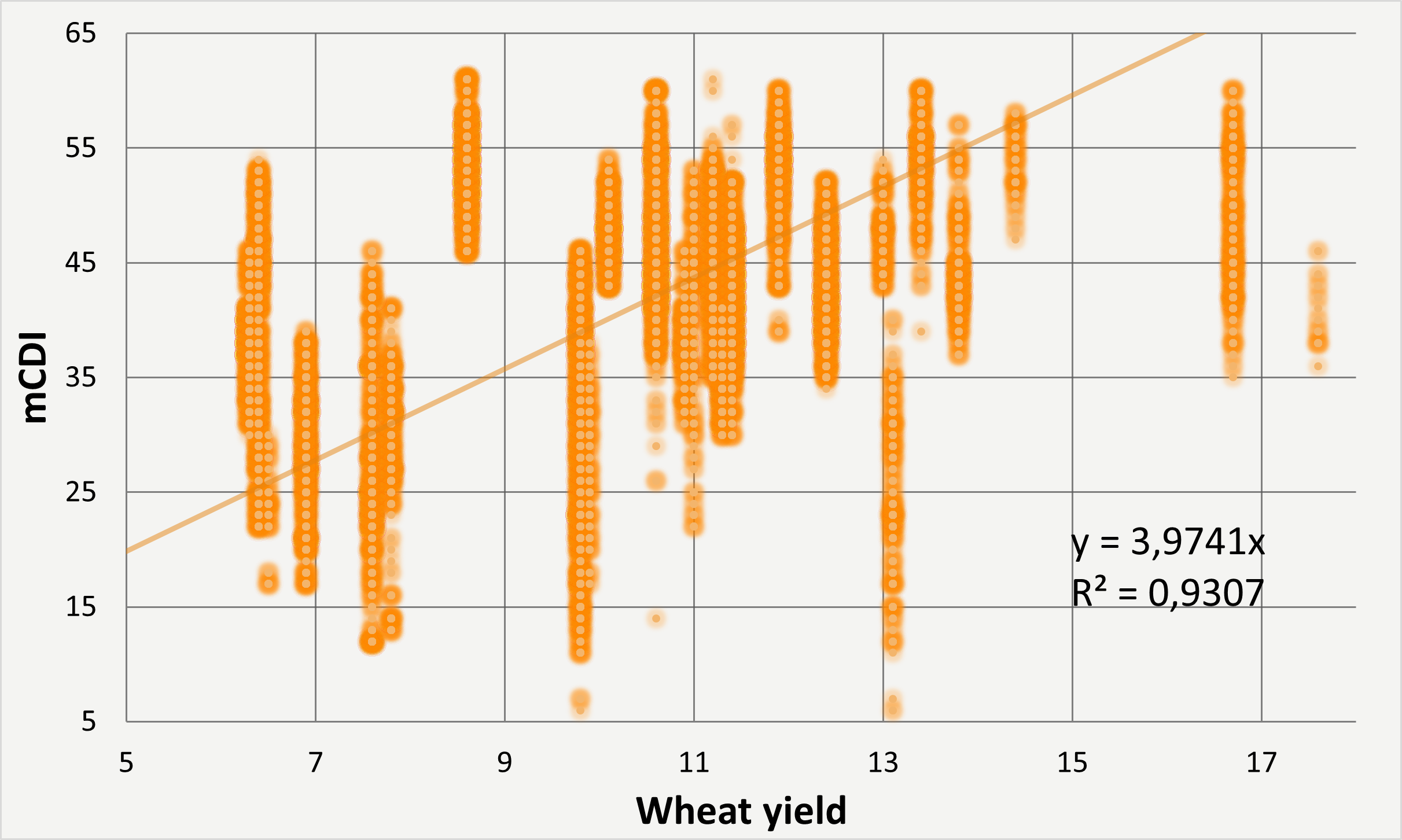
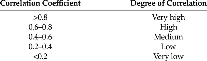
We used the digitized wheat yield data for 2020 in the Kostanay region to validate the results of mCDI and calculated the correlation coefficient. The correlation coefficient is a statistical measure of the strength of a linear relationship between two variables. In our case, the correlation was very high (R2=0.93), which indicates the high reliability of mCDI in monitoring agricultural drought over the Republic of Kazakhstan.
Agricultural drought prediction
Temporal Fusion Transformer (TFT) deep learning model was used to perform agricultural drought prediction based on the mCDI over the Republic of Kazakhstan.
TFT is a deep learning model that uses the attention mechanism method. It combines high-performance multi-zone forecasting with an interpretable understanding of temporal dynamics. To explore temporal relationships at different scales, TFT uses repetitive layers for local processing and interpretive self-monitoring layers for long-term dependencies.
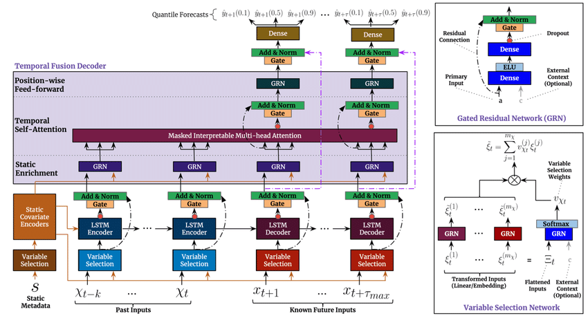
The main advantage of the TFT model over the Transformer model is the ability to use static covariates. Static covariates contain data that is attached to the time series but does not change over time. This allowed us to add additional information, such as latitude/longtitude, climate zone and average elevation data of a particular district.
Prediction Models page contains the results of agricultural drought historical predictions for four, twelve and twenty four weeks using different spatial divisions (1 degree grid & administrative district boundaries). Moreover, the results include three different scenarios (positive [q01], baseline [q05] and negative [q09]) of the course of events. The performed model for four weeks demonstrated outstanding results with average MASE of 0.4-0.6 and drought severity class match of around 85% for baseline scenario. In the case of twelve weeks prediction drought severity class match was around 45% and average MASE increased to 1.6, while twenty four weeks prediction showed insufficient outcome which requires further improvement